
Daylight Parameters
|
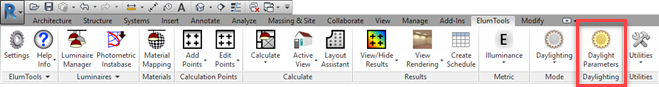
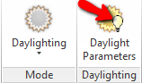
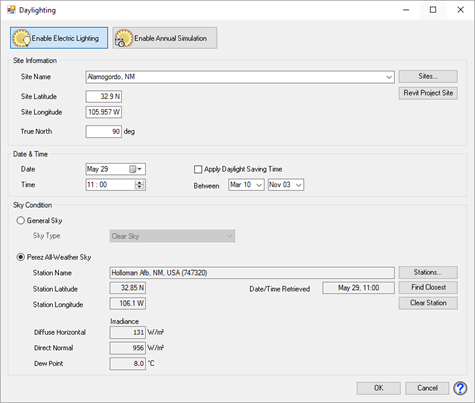
When ElumTools is set in Daylighting mode the Daylight Parameters button becomes active on the end of the ribbon as shown above. Clicking on this button will open the Daylight Parameters dialog (right) allowing you to set the specifics for daylighting calculations.
Enable Electric Lighting in Daylight Calculations - This button provides the On/Off switch for electric lighting when daylighting is enabled. To include the contribution of electrical lighting with daylighting, select this button, it will appear highlighted. This selection is disabled by default (only daylight component is calculated).
When electric lighting is enabled, the icon on the ribbon will include a small light bulb visible on top of the sun. This will also be visible in the Mode menu and tool tip shown when performing calculations.
|
|
Enable Annual Simulation 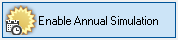
Adjacent to the button to Enable Electric Lighting you will see a button titled Enable Annual Simulation. This capability is provided by Lighting Analysts software program Licaso, sold separately. If you have Licaso installed, any command to calculate in Daylight mode will branch to Licaso if this button is enabled. If Licaso is not present, a web page describing Licaso will be displayed.
When the annual simulation capability is enabled the Daylight Parameters button will appear with a small time clock icon.
![]()
Site location
This section allows you to specify the geographical location of your site and True North orientation. ElumTools will automatically pull the Revit project site latitude, longitude and True North orientation to complete this section.
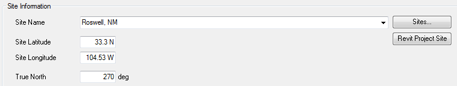
Site Name and Sites button - The Sites button allows you to create a private database of site locations with associated weather files for repeated use. The Revit site information is NOT stored in the database automatically. See Daylighting Site Locations. The drop-down menu is seeded with your locations from the Sites database. The top-most location is the Revit project site.
Revit Project Site - Clicking this button will reset the site currently displayed to the Revit project site: Name, Latitude, Longitude and True North settings.
Site Latitude - This text box echoes the Latitude coordinates for the site location, as chosen from the Revit project, or the Sites database. Alternatively, the latitude may be entered manually. Latitude information is entered in decimal degrees. Latitude is measured north and south from the equator. A positive entry denotes North, a negative entry denotes South. Alternatively, a compass direction can be specified after the angle. Example: 40 N. or 40, 40 S or -40.
Site Longitude - This text box echoes the Longitude coordinates for the site location, as chosen from the Revit project or the Sites database. Alternatively, the longitude may be entered manually. Longitude information is in decimal degrees. Longitude is measured east and west from the Prime Meridian, (the meridian that runs through Greenwich, England). A positive entry denotes West, a negative entry denotes East. Alternatively, a compass direction can be specified after the angle. Example: 105 W. or 105.
True North - ElumTools True North for the site location is specified counterclockwise (CCW) from the positive X-Axis. This is different from the Revit True North which is specified CCW from the positive Y-axis. Therefore, a Revit True North setting of 0 degrees is identical to an ElumTools True North setting of 90 degrees. ElumTools behavior is consistent with IES LM-72-03 (R2010) "Directional Positioning of Photometric Data".
The orientation of True North will be pulled from the Revit project information the first time you enter the dialog. If it is not, exit the dialog and set the Orientation property of a plan view (the current view) to True North. Re-select the ElumTools Daylight Settings command.
Date & Time
Select the calendar date and the time of day for the analysis. Time of day is based on a 24-hour clock (no AM or PM). Example: 1:14 AM would be entered as 01:14, while 1:14 PM would be entered as 13:14. ElumTools will warn if the sun is below the horizon for the date and time selected. Daylight calculations are not valid for dawn or twilight conditions.
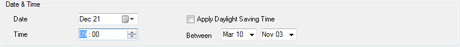
Daylight Saving Time (DST) - If Daylight Saving Time is used for the project site, select the check box for Apply Daylight Saving Time and set the range of dates for which it applies at this location. (Dates vary with year and country.)
For example: If Apply DST is specified for March 10 through November 3, and the Date for the analysis is April 16, the time for each calculation for this date will be adjusted for Daylight Saving Time. If the Time is set at 10:00, the time for the calculation will be 09:00.
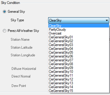
Sky Condition
|
The sky condition may be specified as either General Sky, which uses a CIE or IES general sky type, or Perez All-Weather Sky, which will use data from a selected weather station (TMY format).
General Sky - If General Sky is selected, ElumTools will use the IES and CIE accepted sky models to calculate the sky's contribution in the daylight calculations. The IES and CIE recognize the Kittler model (Clear Sky) and the Moon and Spencer model (Overcast Sky), as well as 15 additional Standard General Sky models. The IES further recognizes the Pierpoint (Partly Cloudy) model. |
|
The CIE mathematically defines fifteen sky types in CIE Publication S 011/E:2003, Spatial Distributions of Daylight - CIE Standard General Skies. The relative sky luminance distributions are described in the following table:
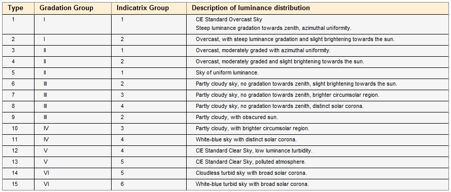
Gradation Group - indicates the gradation between horizon and zenith.
Indicatrix Group - indicates the scattering function, which relates the luminance of a sky element to its angular distance to the sun.
These models provide mean data averaged over a variety of time, location and measurement conditions.
The IES Handbook states that the traditional sky models (Clear, Partly Cloudy and Overcast) should not be compared to instantaneous sky conditions (especially for a partly cloudy sky, where the sky luminance distribution can change rapidly and significantly as the sun is revealed, partially obstructed or fully obstructed). It is not unusual for the instantaneous measured sky luminance to differ from the average mean value by a factor of 2 from measurement to measurement.
The CIE states that the Standard General Sky models (1 - 15) give an approximation to clear, overcast, and skies of broken clouds that are sufficiently accurate for most daylight calculations.
Perez All Weather Sky
When the Perez All-Weather sky is selected, ElumTools will use the data from the selected weather station to determine the likely sky and atmospheric conditions for that location, date and time.
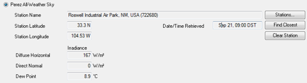
Station Name - The selected weather station. The station may be selected by clicking on the Stations button or on the Find Closest button. When a weather station has been selected, its Latitude and Longitude are displayed. If a site location is being retrieved from the sites database, the weather file will already be associated and referenced.
Stations - Opens the Weather Stations dialog, with the stations nearest the site location listed. A weather station may be selected this way, or a previous selection may be changed.
Find Closest - Selects and loads the name, latitude and longitude of the nearest weather station to the specified site coordinates. Once selected, clicking on the Stations button will show the distance the selected station is from the site.
Clear Station - Removes the Station Name and all of the data associated with it.
Date/Time Retrieved - ElumTools uses the "Floor" method which rounds down to the nearest whole hour. For example, if the Time is set to 08:15 the data returned would be for 08:00. If the Time was 08:35, the weather data for 08:00 would still be used.
All data in the weather database is based on standard time. Therefore, if Daylight Saving Time is selected (Date/Time section), the Time is adjusted when retrieving data from the weather database (-1 hour), and a note is displayed indicating the Date/Time Retrieved has been "Adjusted for Daylight Saving Time."
Diffuse Horizontal Irradiance, Direct Normal Irradiance, and Dew Point Temperature: These parameters are necessary to perform daylighting calculations using the Perez Sky Model and are automatically extracted from the weather database. A high Diffuse Horizontal Irradiance value is a good indication of an overcast condition, while conversely, a high Direct Normal Irradiance would indicate a clear sky condition.